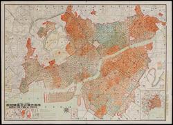
Map of the Path of the Conflagration from the Great Earthquake in the Imperial Capital
Ono Kenjin
(Japanese, active about 1923–1938)
1923 (Taishô 12)
Medium/TechniqueLithograph; ink and color on paper
DimensionsHeight x width: 79.3 × 109.5 cm (31 1/4 × 43 1/8 in.)
Credit LineJohn Ware Willard Fund
Accession number2022.130
On View
Not on viewClassificationsPrints
Provenance2022, sold by Geographicus, Brooklyn, NY to the MFA. (Accession date: April 20, 2022)


Tokyo Printing Company (Tokyo insatsu kabushiki kaisha)
about 1908

Tokyo Printing Company (Tokyo insatsu kabushiki kaisha)
about 1908

Tokyo Printing Company (Tokyo insatsu kabushiki kaisha)
1908